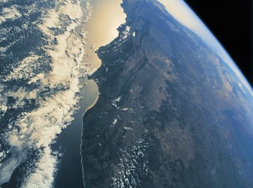

Free satellite pictures are available from dozens of online sources, including Google, government sources like NASA and NOAA, and images from private firms. The wonders of modern technology, both space travel and the internet, have combined to make it easy to find high-quality satellite photos for just about any spot on Earth.
Google Earth
The Google Earth web application combines satellite imagery from multiple sources with aerial photography. The result is an interactive map of our planet. You can zoom in, zoom out, search by address and probably find your house. You can navigate to pretty much any point on earth in order to explore the available images. Although not every photograph is the absolute latest in satellite imagery, the overall tool is so much fun that it's definitely worth exploring.
U.S. Government Sources
Several agencies of the United States government make up-to-date satellite imagery available online, including the National Aeronautics and Space Administration, the National Oceanographic and Atmospheric Administration and the U.S. Geological Survey. You may be more familiar with these organizations by their commonly used initials: NASA, NOAA and USGS. The photographs cover a broad range of applications, from true-color images to specialty images such as infrared and radar that are used to explore the planet's weather systems, environmental health, biological resources and geology.
Other Government Sources
The U.S. is not the only provider of imagery, of course. Other government agencies, from the European Space Agency to India's National Remote Sensing Center, also make high-quality and up-to-date satellite images available. You can also access images from China, Brazil and several other nations.
Private Sources
Commercial companies typically charge for access to satellite imagery, but they often provide limited access to some of their latest images, especially when connected to a breaking news story such as a dramatic storm or tsunami. Visit TerraServer to view a large collection of images for free and DigitalGlobe to find the latest free photos that the firm makes available.
References
About the Author
David Sarokin is an ecologist and noted environmentalist with more than 30 years experience in environmental policy. He created the nation's Right-to-Know program for chemical pollutants, and is the author of Missed Information (MIT Press, 2016), detailing how our social systems like health care, finance and government can be improved with better quality information.
Photo Credits
Stockbyte/Stockbyte/Getty Images